
Cartography
-

# 17973
BRUÉ, Adrian Hubert
A rare cased atlas of eight large folding maps of the world
Paris : Chez J. Goujon et J. Andriveau, 1827. A large book-form box made of stiff card, 250 mm tall, gilt-decorated papered sides, silk draw ribbon, the ‘spine’ made of crushed morocco styled in compartments, with gilt ornamentation and the lettering ‘Atlas par H. Brué’, listing the eight maps contained within: ‘Mappemonde; Europe; Asie; Afrique; …
-
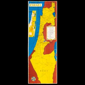
# 26514
ISRAEL GOVERNMENT TOURIST CORPORATION
Touring map of Israel
Jerusalem : Government Tourist Corporation, circa 1952. Map printed in colour, 682 x 240 mm, folded, showing the armistice lines, major highways and distances between major townships and cities, tourist information verso, a couple of wet stamps from a Vancouver tourist office, a couple of creases overall very good. Scarce early map of the state …
-

# 32580
HERISSON, Eustache ; BONNE, Rigobert
Carte générale de l’Europe, ou l’on voit le départ et le retour du Capne. Cook, dans ses differéns voyages.
Dressée par Hérisson, Eleve de Mr. Bonne, ancien Ingénieur Hydrographe de la Marine. A Paris : chez Basset Md d’Estampes Rue Jacques au coin de celle des Mathurins, no. 670, 1802. Copperplate engraving, original outline hand colour, 525 x 755 mm (image), old folds as issued, a fine example. Map of Europe showing the departures …
-

# 31523
PHILLIP, Arthur (1738-1814)
The Voyage of Governor Phillip to Botany Bay (coloured edition)
with an account of the establishment of the Colonies of Port Jackson & Norfolk Island; compiled from authentic papers, which have been obtained from the several departments, to which are added, the journals of Lieuts. Shortland, Watts, Ball, & Capt. Marshall; with an account of their new discoveries. London : John Stockdale, 1789. Quarto, contemporary …
-
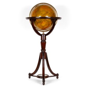
# 31926
MALBY & Co.
Malby’s terrestrial globe
Compiled from the latest and most authentic sources, including all the recent geographical discoveries, manufactured and published under the superintendence of the Society for the Diffusion of Useful Knowledge by Malby & Sons, Globe & Map Sellers to the Admiralty. Published at the Globe Manufactory, 37 Little Parker Street, Little Queen Street, Holborn, London, [circa …
-

# 32074
WEYGAND, F. J.
Globe artificiel et mécanique a l’usage du petit géographe.
Amsterdam : La Haye [Netherlands] : F.J. Weygand, n.d. [c.1840]. Collapsible globe in 6 gores, engraved with hand colouring, laid down on thin card, each gore 170 x 70 mm (irregular); in fine condition with vivid original colour, Australia with Terre de Witt, Terre d’Eendracht, Cape Leeuwin, Terre de Nuyts, Golfe de Spencer, Terre de Van …
-
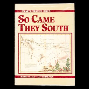
# 31856
CLANCY, Robert ; RICHARDSON, Alan
So came they south
Sydney : Shakespeare Head Press, 1988. Quarto, boards in dustjacket (spine slightly faded), maps to endpapers, pp. 176, illustrated. The mapping and exploration of Australia and New Zealand by the early European explorers.
-

# 31751
HUGHES, Sydney G.
Pocket map of Brisbane
Brisbane : Published by Sydney G. Hughes, [1943]. Colour map, 470 x 350 mm, folding to 170 x 100 mm, in original pictorial card covers, 190 x 110 mm (light vertical crease), verso of map with printed information for tourists on Brisbane and neighbouring centres.
-

# 31434
DARTON, William
38 maps. Union atlas, containing new and improved maps of all the Empires, Kingdoms and States in the known world,
designed as a companion to the various gazetteers & books of geography now in use, the whole clearly engraved by artists of eminence and carefully coloured. Including maps of the Roman Empire and Ancient Greece. London : William Darton, Jan. 25th 1812 (the maps dated between 1811 – 1812). First edition. Quarto, modern binding of half …
-
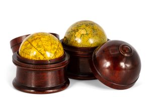
# 31431
NEWTON & SON
A matching pair of cased terrestrial and celestial pocket globes.
Newton’s new & improved terrestrial globe containing the latest discoveries. [London] : Published by J. Newton & Son, 66 Chancery Lane, & 3 Fleet St., Temple Bar [between 1852-58]. Terrestrial globe, 3 inches in diameter, hand-coloured printed gores over plaster base, two metal pins, housed in the original hand-turned mahogany case; inscribed on the base ‘G. Phillips, …
-
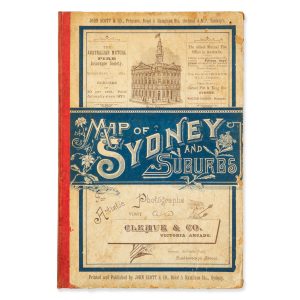
# 30138
SCOTT, John
Map of the City of Sydney and adjacent municipalities from ordnance and actual surveys 1890
Cover title : Map of Sydney and Suburbs. Sydney : John Scott & Co., 1890. Chromolithograph map, 94 x 82.8 cm, folding, occasional light foxing, short splits along folds, housed in original folder, papered boards with cloth spine, pp. [vi], advertisements. A fine late Victorian map from Curl Curl to Botany Bay, extending west to …
-

# 27985
Dépôt de la guerre
Carte topographique des environs d’Alger
d’Aprés les levés et les reconnaissances des Officiers d’Etat-major et autres documents. Paris : Publiée par le Depôt de la Guerre; Imprimerie chez Kaeppelin, 1856. Engraved by Erhard Schieble. Engraved map, dissected and laid on linen, 680 x 1010 mm, printed label. French colonial map of Algeria, invaded by the French in 1830 and occupied with much …
-

# 28179
STANFORD, Edward
A map of China prepared for the China Inland Mission 1923.
London : China Inland Mission and Edward Stanford, 1923. Map printed in colour, 1060 x 880 mm, dissected and laid on linen, pale waterstain, cloth slipcase lettered in gilt (discoloured), overall in good condition. A detailed map showing Protestant missions across Eastern China.
-
# 27284
[GUGK] ABDULLAEV, I. K., et al
Атлас Азербайджанской Советской Социалистической Республики. / Atlas Azerbaĭdzhanskoĭ Sovetskoĭ Sot︠s︡ialisticheskoĭ Respubliki.
Baku : GUGK (Glav. upravlenie geodezii i kartografii, 1963. Folio (330 x 225 mm), publisher’s green cloth over boards (a few scuff marks) with embossed GUGK crest and gold lettering to upper board, pp x, 213; chiefly colour maps with differing scales (some folded), colour diagrams; errata slip inserted; text in Russian; contents very clean …
-
![[CHINA] Proceedings of the Royal Geographical Society and Monthly Record of Geography. Vol. II, no. 3, New Monthly Series. March, 1880.](https://dsfb-wp.s3.ap-southeast-1.amazonaws.com/app/uploads/2021/03/19102440/2021_DSFB_1622-300x300.jpg)
# 28578
MORRISON, Gabriel James (1840-1905); HOLUB, Emil (1847-1902)
[CHINA] Proceedings of the Royal Geographical Society and Monthly Record of Geography. Vol. II, no. 3, New Monthly Series. March, 1880.
London : Printed by William Clowes & Sons, [1880]. Tall octavo (245 mm), original printed blue wrappers (lightly marked, small paper loss at spine ends), pp 1-8 (advertisements), 145-208; folding colour plate at the rear with two Maps to Accompany Papers on Journeys in Eastern China by G. J. Morrison, M. I. C. E., 1878, which …
-
![[MISSIONS; JAPAN] Japonska](https://dsfb-wp.s3.ap-southeast-1.amazonaws.com/app/uploads/2021/03/19102426/2021_DSFB_1618-300x300.jpg)
# 28334
PETELIN, Stanko (author); BRESKVAR, Silvo (illustrator)
[MISSIONS; JAPAN] Japonska
Domžale [Ljubljana] : “Unio Cleri” Misijonska tiskarna [Missionary Press], 1936. Series: “Unio Cleri” Miss. pro Jugoslavia, IX. Octavo (180 mm), original printed wrappers (sunned and lightly foxed), staple bound; 56 pp, 3 maps (one double-page); clean throughout, a good copy; with an inserted original mimeographed advertisement for the Missionary Press (toning and pale foxing). A …